Publications
- Orcid ID: 0000-0002-5153-303X
- Google Scholar: aafNVpUAAAAJ&hl
2025
2025
- Present-Day Thermal State and Surface Heat Flux of the MoonSabatino Santangelo , Ana-Catalina Plesa , Adrien Broquet, and 2 more authorsJournal of Geophysical Research: Planets, 2025e2025JE009458 2025JE009458
Abstract The concentration of volcanic material and Heat-Producing Elements (HPE) on the lunar nearside surface suggests an asymmetry of interior properties and thermal history between the two hemispheres. However, the distribution of HPE beneath the surface and the processes that led to their potential enrichment on the nearside remain poorly understood. Here, we use a 3D geodynamic model to infer the interior distribution of HPE based on surface heat flux estimates. We explore the consequences of a putative HPE-rich unit underneath the Procellarum region on the lateral variations of the present-day surface heat flux. Assuming a circular geometry and 1.6 km average thickness, we explore various sizes, locations, and enrichments of the HPE-rich unit, including the complete absence of such an anomaly, and select successful scenarios based on models that match the Apollo heat flux measurements. Scenarios with either a homogeneous HPE distribution in the mantle or a globally uniform HPE-rich layer lead to surface heat fluxes inconsistent with Apollo data. Conversely, a HPE anomaly beneath the nearside, extending at least to the Apollo 15 landing site and at most encircling the entire mare region, including Apollo 17 landing site, can match both measurements. The required Th concentration within the anomaly ranges from 23 to 50 ppm, assuming a 1.6 km thickness. Finally, we predict heat flux ranges of 7–12 mW/ {\mathrmm^2 and 8–14 mW/ {\mathrmm^2 for the upcoming Blue Ghost Mission 1 and APEX®1.0 heat flux measurements.
- Compensation State and Geophysical Evolution of Sputnik Basin on PlutoS. A. Moruzzi , J. C. Andrews-Hanna , A. Broquet, and 1 more authorJournal of Geophysical Research: Planets, 2025e2025JE009125 2025JE009125
Abstract Sputnik basin is an ∼2,000 × 1,000 km elongated impact basin located in the equatorial region of Pluto. It contains a low-viscosity N2-rich ice deposit that has prompted comparisons between the Sputnik basin and mascon basins in the inner Solar System—some of which were initially isostatically compensated by the uplift of high-density mantle materials in the subsurface and evolved to a mass excess from the lithospheric support of infilling material. In the absence of gravitational data, novel approaches must be considered to examine the structure of the Sputnik basin. Here, we assume that the surface of the low-viscosity infill conforms to Pluto’s geoid, and we use this constraint to evaluate the local gravity field over the basin considering a range of ice shell and N2-deposit thicknesses. Our results show that an isostatically compensated pre-fill Sputnik basin has a strongly negative free-air gravity anomaly due to the attenuation of the gravity signature through Pluto’s relatively thick ice shell compared to the mean radius. The best fit models to the Sputnik basin reflect a present-day mass deficit and a largely uncompensated basin, which is at odds with previous work suggesting a past mass excess and overcompensated basin. To reconcile these findings, we propose that the substantially thinned post-impact ice shell beneath the basin was out of thermal equilibrium, leading to the refreezing of the uplifted ocean and to the basin transitioning to a present-day mass deficit. This new evolutionary pathway has important implications for Pluto’s interior structure and the evolution, and longevity, of a subsurface ocean.
-
 Southward impact excavated magma ocean at the lunar South Pole–Aitken basinJ. C. Andrews-Hanna , W. F. Bottke , A. Broquet, and 10 more authorsNature, 2025
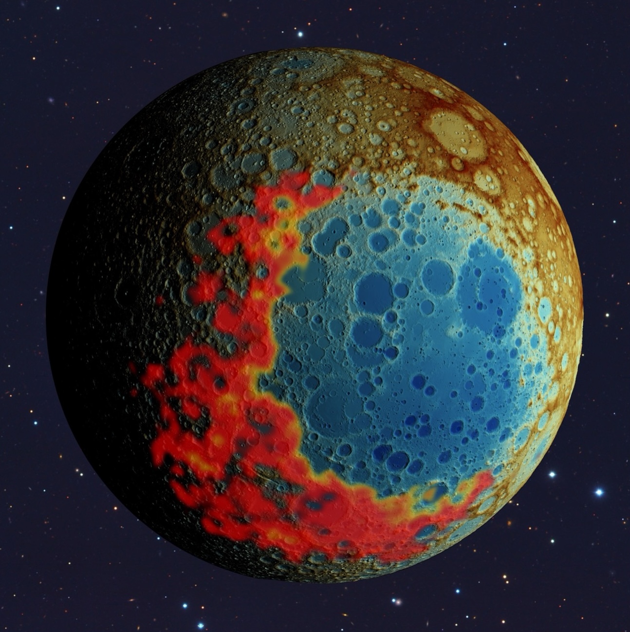
The ancient South Pole–Aitken impact basin provides a key data point for our understanding of the evolution of the Moon, as it formed during the earliest pre-Nectarian epoch of lunar history, excavated more deeply than any other known impact basin and is found on the lunar far side, about which less is known than the well-explored near side. Here we show that the tapering of the basin outline and the more gradual topographic and crustal thickness transition towards the south support a southward impact trajectory, opposite of that commonly assumed. A broad thorium-rich and iron-rich ejecta deposit southwest of the basin is consistent with partial excavation of late-stage magma ocean liquids. These observations indicate that thorium-rich magma ocean liquids persisted only beneath the southwestern half of the basin at the time of impact, matching predictions for the transition from a global magma ocean to a local enrichment of potassium, rare-earth elements and phosphorus (KREEP) in the near-side Procellarum KREEP Terrane. These results have important implications for the upcoming human exploration of the lunar south pole by Artemis, as proposed landing sites are now recognized to sit on the downrange rim and thorium-rich impact ejecta of the basin.
- Evidence for an early formation of Serenitatis basin at 4.25 Ga shifts lunar chronologyE. Bjonnes , C.J. Brandon , A. Broquet, and 4 more authorsGeophysical Research Letter, 2025
Troctolite sample 76535, collected in Serenitatis basin during Apollo 17, formed at least 50 km deep, experienced maximum shock pressures of 6 GPa, and has a 40Ar/39Ar excavation age of 4.25 Ga. Previous work attributed 76535 to the South Pole-Aitken (SPA) basin, presumably dating the SPA-impact and constraining lunar bombardment history. Here we use the iSALE-2D shock-physics code and gravity inversion modeling to determine if instead the Serenitatis impact event excavated 76535. We find nearly 140,000 km3 of material (∼2% of near-surface ejecta) matching the depth and pressure constraints of 76535 is displaced to the surface during crater collapse of a Serenitatis-like impact event. We conclude that the Serenitatis impact event possibly excavated 76535, redefining its age to 4.25 Ga, 300 My older than the consensus age based on Apollo 17 samples. This finding would provide an important anchor point where lunar chronology where bombardment flux is especially uncertain.
-
 On the Crustal Architecture of the Terrestrial PlanetsA. Broquet, J. Maia , and M.A. WieczorekJournal of Geophysical Research: Planets, 2025
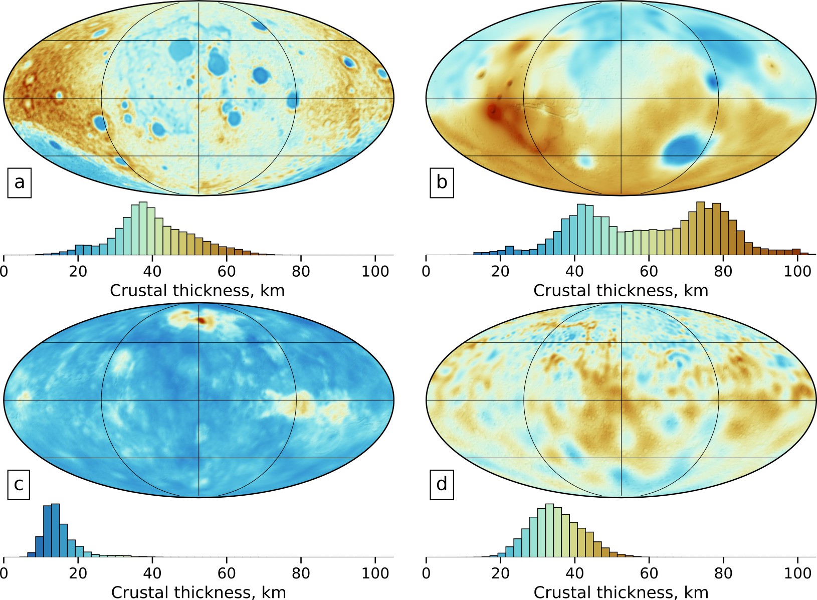
Abstract Understanding the structure and composition of planetary crusts is fundamental for unraveling the diverse geologic pathways of rocky bodies in the solar system. In recent years, geophysical missions have shed light on the crustal architecture of the Moon and Mars. New missions are currently en route to Mercury and in preparation for Venus. Here, we provide an overview of our current knowledge of the crustal structure of the Moon, Mars, Mercury and Venus, and present nominal models for these planets. Planetary crusts are thought to have average thicknesses of ∼20 km (Venus), ∼30 km (Mercury, Moon) and higher (30–70 km, Mars), and generally represent a few percent of the silicate mass fraction of their planet. In comparison, crustal thickness on Earth is bimodal, with values of 40 and 7 km for the continental and oceanic crusts, respectively, for a global average of ∼19 km. We highlight that gravity inversions must account for the often-uneven resolution of gravity fields and show that the classical Bouguer anomaly filtering step can be avoided by simultaneously inverting for crustal density and thickness. Rather than discarding data, this method ascribes short-wavelength gravity anomalies to crustal density variations. For Mercury, Venus, and the Moon, we discuss the effect of having a laterally variable mantle density on crustal thickness inversions, and for Mars, we present an approach to consider a high-density basaltic crust. While crustal thickness inversions remain non-unique, we discuss that the distribution of tectonic and volcanic landforms can help constrain the range of plausible models.
- Gravity and Magnetic Field Signatures in Hydrothermally Affected Regions on MarsA. Mittelholz , M. Moorkamp , A. Broquet, and 1 more authorJournal of Geophysical Research: Planets, 2025
Multiple lines of evidence indicate that liquid water-rock interactions occurred on ancient Mars, particularly within the crust, where hydrothermal systems have been hypothesized. Such hydrothermal circulation (HC) can significantly lower temperatures in the crust, thereby restricting the viscoelastic relaxation of impact craters. Craters with minimal relaxation are characterized by their large depth-to-diameter ratio and prominent Bouguer gravity anomalies. Additionally, HC can induce magnetic anomalies through chemical remanent magnetization (CRM). Consequently, if HC was widespread on Mars, the gravitational signatures of unrelaxed craters may correlate with their magnetic signatures. To investigate how HC influenced the magnetic characteristics of the Martian crust, we focus on the region surrounding several unrelaxed craters in the southern highlands, where hydrothermal activity was likely prevalent. We use a newly developed joint inversion approach and model magnetization and density in such regions to investigate how hydrothermal systems affect those parameters. The inversion approach makes use of a mutual information term in which models with a parameter relationship are favored, that is, models in which magnetization and density distributions are correlated. Despite showing large Bouguer gravity anomalies and forming over 3.75 billion years ago, when the Martian dynamo was most likely active, investigated craters and surrounding regions exhibit minimal magnetic anomalies. We propose that this lack of magnetic signatures is most likely due to demagnetization of the crust through CRM, induced by HC long after the Martian dynamo ceased. Our findings suggest that deep, long-lived hydrothermal systems—likely fueled by heat-producing elements—were present, potentially creating habitable conditions on early Mars.
-
 Glacial isostatic adjustment reveals Mars’s interior viscosity structureA. Broquet, A.-C. Plesa , V. Klemann , and 6 more authorsNature, 2025
Investigating glacial isostatic adjustment has been the standard method to decipher Earth’s interior viscosity structure, but such an approach has been rarely applied to other planets because of a lack of observational data. The north polar cap of Mars is the only millions-of-years-old surface feature that can induce measurable surface deformation on this planet, thereby holding clues to its present-day internal viscosity structure. Here we investigate the emplacement of this ice cap by combining thermal evolution models, viscoelastic deformation calculations and radar observations. We show that downward motion of the northern regions is ongoing and can be constrained by analyses of the time-variable gravity field and NASA’s InSight seismic moment rate. Only models with present-day high viscosities (2–6 1022 Pa s for depths greater than 500 km), strong mantle depletion in radiogenic elements (more than 90%) and thick average crusts (thicker than 40 km) are consistent with the negligible flexure beneath the polar cap seen by radars. The northern lithosphere must deform at less than 0.13 mm per year and have a seismic efficiency less than 0.3 to satisfy gravity and seismic constraints, respectively. Our models show that the north polar cap formed over the last 1.7–12.0 Myr and that glacial isostatic adjustment can be further constrained by future gravity recovery missions to Mars.
2024
2024
- Relaxation States of Large Impact Basins on Mercury Based on MESSENGER DataC. Szczech , A. Broquet, A.-C. Plesa , and 4 more authorsGeophysical Research Letters, 2024
The crustal structure of Mercury’s large impact basins provides valuable insights into the planet’s geological history. For a warm crust, a post-impact basin structure will viscously relax with inward flow of crustal materials toward the basin center. This effect drastically diminishes the crustal thickness contrasts and associated Bouguer gravity contrasts between the basin center and its surroundings. Here, we analyze Bouguer contrasts of 36 basins (diameter >300 km) located in the northern hemisphere as a proxy for viscoelastic relaxation. Thermal evolution models, assuming the present 3:2 spin-orbit configuration, are used to predict crustal temperatures. Our analysis reveals that the expected correlation between zones of warm crust and low Bouguer contrast from relaxation is not observed in the available data. This suggests that crustal temperatures have changed in the past, potentially due to a change in Mercury’s orbit or to a major volcanic event associated with smooth plain formation.
-
 Mercury’s Crustal Porosity as Constrained by the Planet’s Bombardment HistoryA. Broquet, F. Rolser , [Dual first authorship] , and 3 more authorsGeophysical Research Letters, 2024
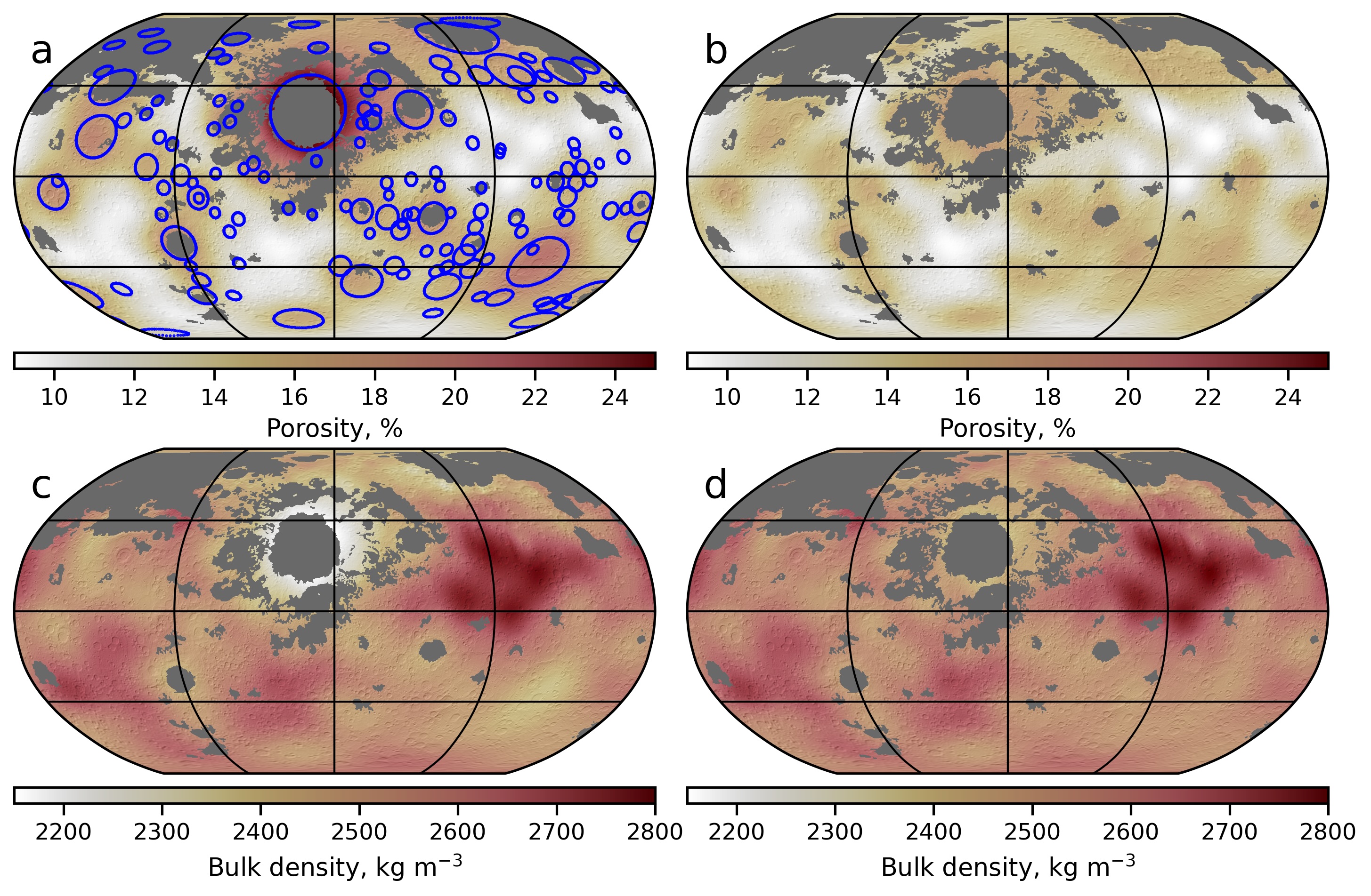
Knowing the structure of the crust is critical to understanding a planet’s geologic evolution. Crustal thickness inversions rely on bulk density estimates, which are primarily affected by porosity. Due to the absence of high-resolution gravity data, Mercury’s crustal porosity has remained unknown. Here, we use a model that was calibrated to the Moon to relate Mercury’s impact crater population and long-wavelength crustal porosity in the cratered terrains. Therein, porosity is created by large impacts and then decreased as the surface ages due to pore compaction by smaller impacts and overburden pressure. Our models fit independent gravity-derived porosity estimates in the northern regions, where data is well resolved. Porosity in the cratered terrains is found to be 9%–18% with an average and standard deviation of 13% ± 2%, indicating lunar-like crustal bulk densities of 2,565 ± 70 kg m−3 from which updated crustal thickness maps are constructed.
-
 Vestiges of a lunar ilmenite layer following mantle overturn revealed by gravity dataW. Liang , A. Broquet, [Dual first authorship] , and 4 more authorsNature Geoscience, 2024
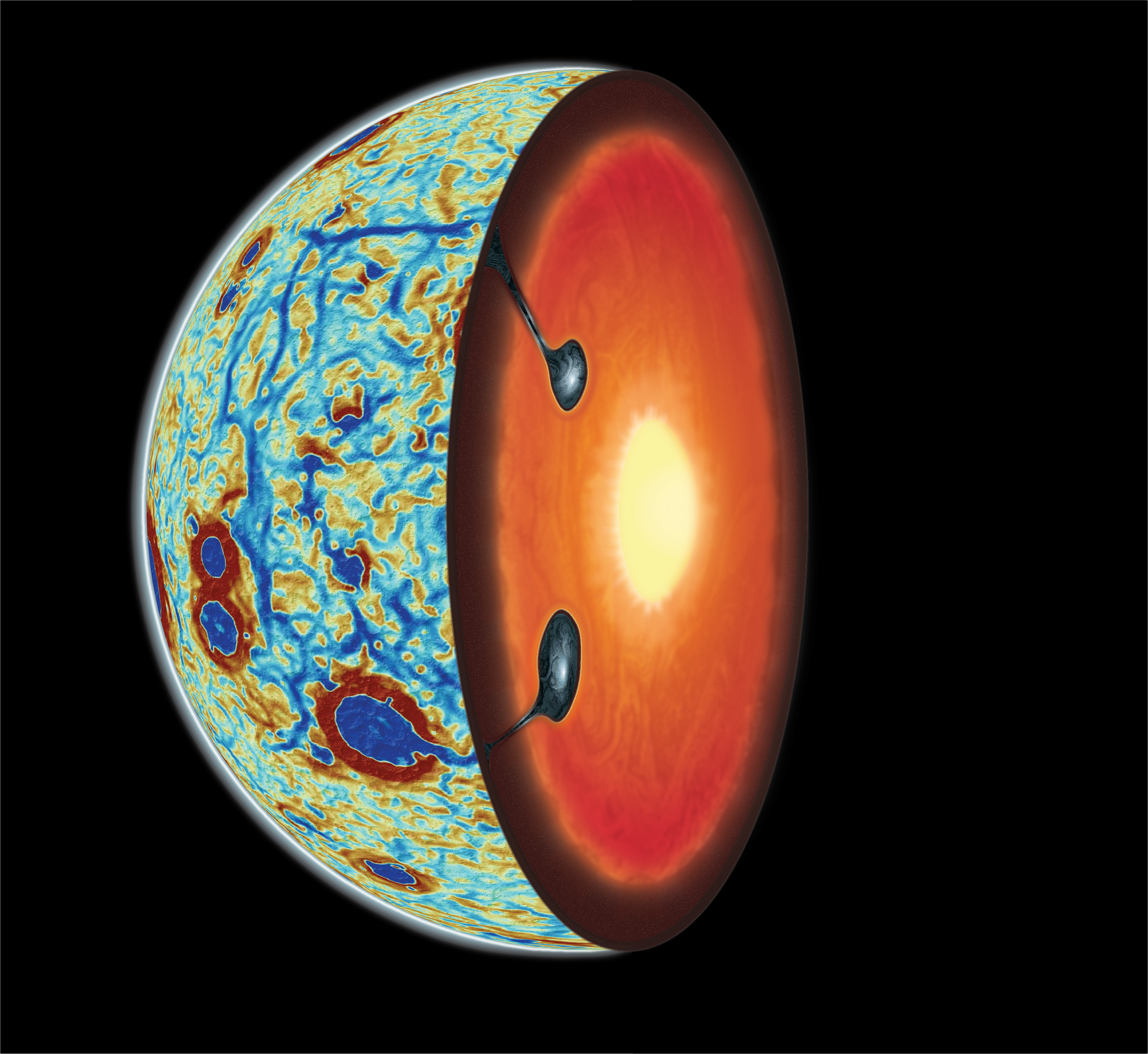
The lunar crust and mantle formed through the crystallization of a magma ocean, culminating in a solid cumulate mantle with a layer of dense ilmenite-bearing cumulates rich in incompatible elements forming above less dense cumulates. This gravitationally unstable configuration probably resulted in a global mantle overturn, with ilmenite-bearing cumulates sinking into the interior. However, despite abundant geochemical evidence, there has been a lack of physical evidence on the nature of the overturn. Here we combine gravity inversions together with geodynamic models to shed light on this critical stage of lunar evolution. We show that the observed polygonal pattern of linear gravity anomalies that surround the nearside mare region is consistent with the signature of the ilmenite-bearing cumulates that remained after the global mantle overturn at the locations of past sheet-like downwellings. This interpretation is supported by the compelling similarity between the observed pattern, magnitude and dimensions of the gravity anomalies and those predicted by geodynamic models of the ilmenite-bearing cumulate remnants. These features provide physical evidence for the nature of the global mantle overturn, constrain the overturn to have occurred before the Serenitatis and Humorum basin-forming impacts and support a deep Ti-rich mantle source for the high-Ti basalts.
-
 A volcanic inventory of the MoonA. Broquet, and J.C. Andrews-HannaIcarus, 2024
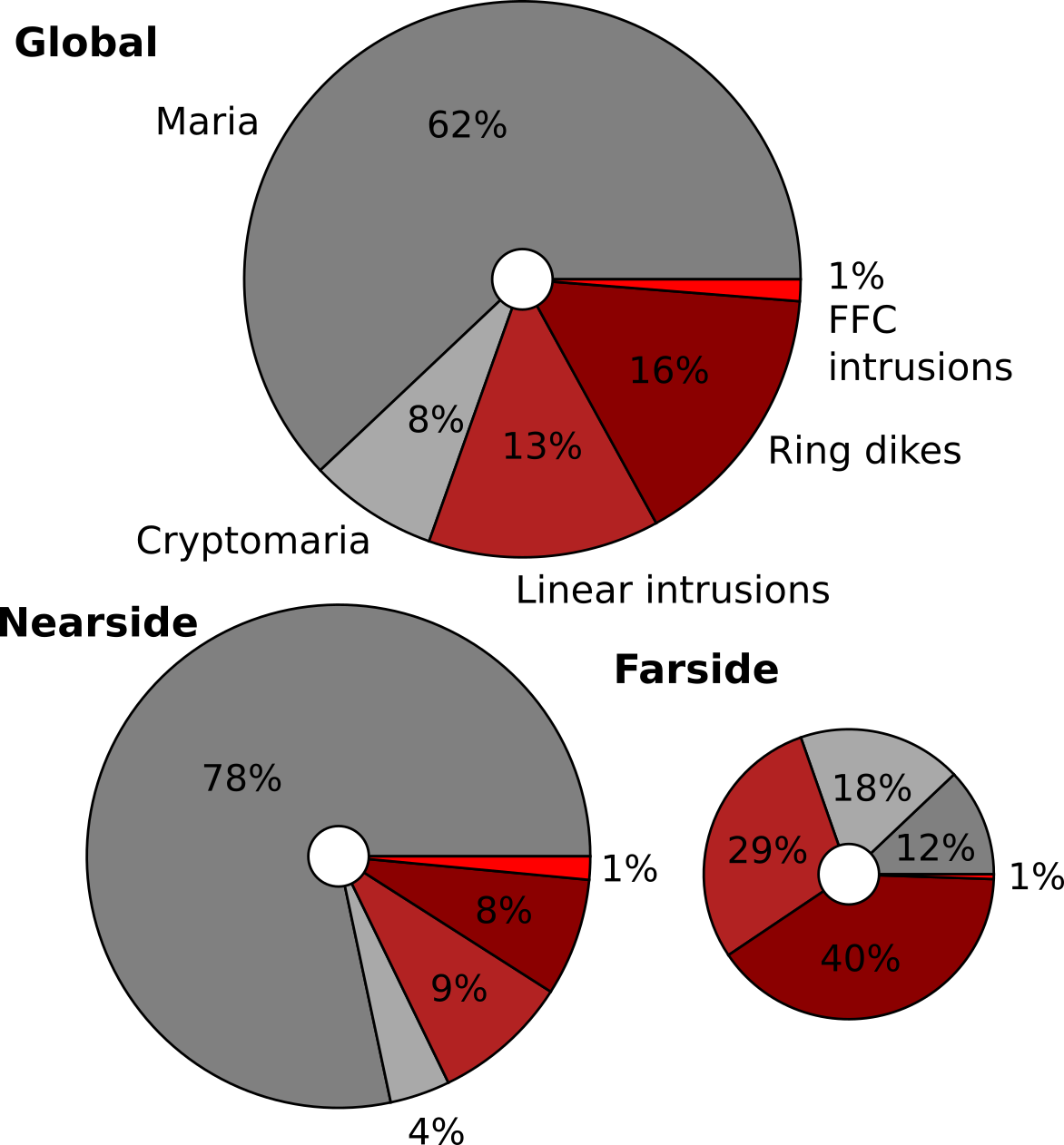
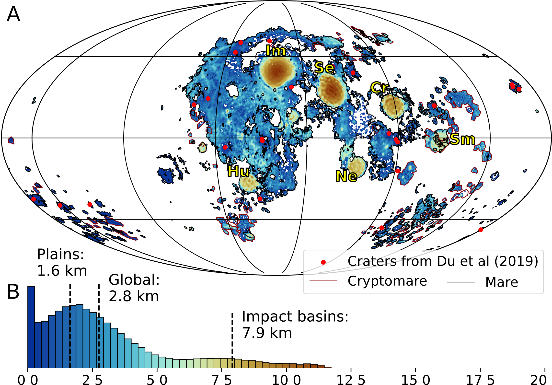
The volcanic and magmatic activity of the Moon is intimately tied to its internal thermal and geodynamic evolution through time. While the extrusive nearside maria dominate the volcanic record, little is known regarding their underlying structure and the details of their emplacement. Intrusive activity is even more enigmatic, with most intrusions expressing little to no surface signature. Although prior studies have provided insights into the local igneous activity, no global compilation has been conducted. Here, we present a volumetric inventory of extrusive and intrusive activity. Gravity and topography data are inverted using a two-layer loading model to constrain mare and cryptomare thickness. The mean thickness of mare units is found to be 2.8 km, though with substantial lateral variations, with average values of 7.9 km within large mare basins compared to 1.6 km outside of these basins. This substantial variation in mare thickness associated with minimal change in the surface topography may be explained by some combination of long-distance transport of low viscosity mare and/or a buoyancy control limiting mare eruptions to a constant level surface. Our preferred volumes of mare and cryptomare are 18.2×10⁶ km3 and 2.2×10⁶ km3, respectively. Crustal intrusions associated with linear gravity anomalies, floor-fractured craters, ring dikes, graben, and beneath volcanic constructs, are investigated and yield a total volume of 9.1×10⁶ km3. Our inventory reveals that intrusive activity dominates in the farside (intrusive:extrusive ratio of 5:2), whereas extrusive volcanism is more pronounced in the nearside (1:5). The combined volume of intrusives and extrusives is found to be 3 times greater in the nearside than in the farside. Both are related to the lunar asymmetry in which the thinner crust and warmer subsurface beneath the Procellarum KREEP terrane enables enhanced melting and magma ascent. These observations may have implications for the interpretation of the thermal and geodynamic history of other celestial bodies, where intrusive volcanism remains poorly constrained.
-
 The Moon before mareA. Broquet, and J.C. Andrews-HannaIcarus, 2024
The crust of the Moon experienced a unique geodynamic evolution, beginning with its crystallization from a magma ocean, continuing through a period of heavy impact bombardment, and followed by extensive basaltic mare volcanism. All these events have left crucial records imprinted in the form of topographic features and gravity anomalies. Here, we invert gravity and topography data using a two-layer thin-shell loading model under the premise of pre-mare isostasy to investigate the global structure of the crust and solve for feldspathic crust and mare thickness, together with mare-induced flexure. The tectonic record and partially buried crater population are used to constrain the bulk of mare volcanism to have been emplaced on a 40 km elastic lithosphere, although mare within large impact basins may have formed on a thinner elastic lithosphere. The mare thickness and associated flexure are removed to calculate a map of the surface and crust of the Moon before mare volcanism. The pre-mare surface in the Oceanus Procellarum region is found to be ∼2 km lower than the surrounding nearside, and several possible explanations, including a giant impact, pore space annealing, isostatic adjustment, and crustal erosion induced by a mantle plume or thermal anomaly, are discussed. The pre-mare elevation map further sheds light on the ring structure of Imbrium, which is seen to resemble that of Orientale. Imbrium’s outermost ring is observed to be at a larger radial distance to the northeast relative to the south, indicating that some level of lithospheric variability affected ring formation at the time of impact. The western part of Imbrium’s ring within Oceanus Procellarum is not found in the pre-mare topography, implying that it either never formed or that some processes erased its signature from gravity and topography. The feldspathic, pre-mare, crust is found to be ∼7 km thinner within large nearside basins than in models not accounting for the high-density mare. The pre-fill floor of these basins was ∼6 km deeper than currently observed, and together with their updated crustal structure, these new insights have implications for impact simulations that try to reproduce the crustal structure of nearside mare basins.
2023
2023
-
 Geophysical evidence for an active mantle plume underneath Elysium Planitia on MarsA. Broquet, and J.C. Andrews-HannaNature Astronomy, 2023
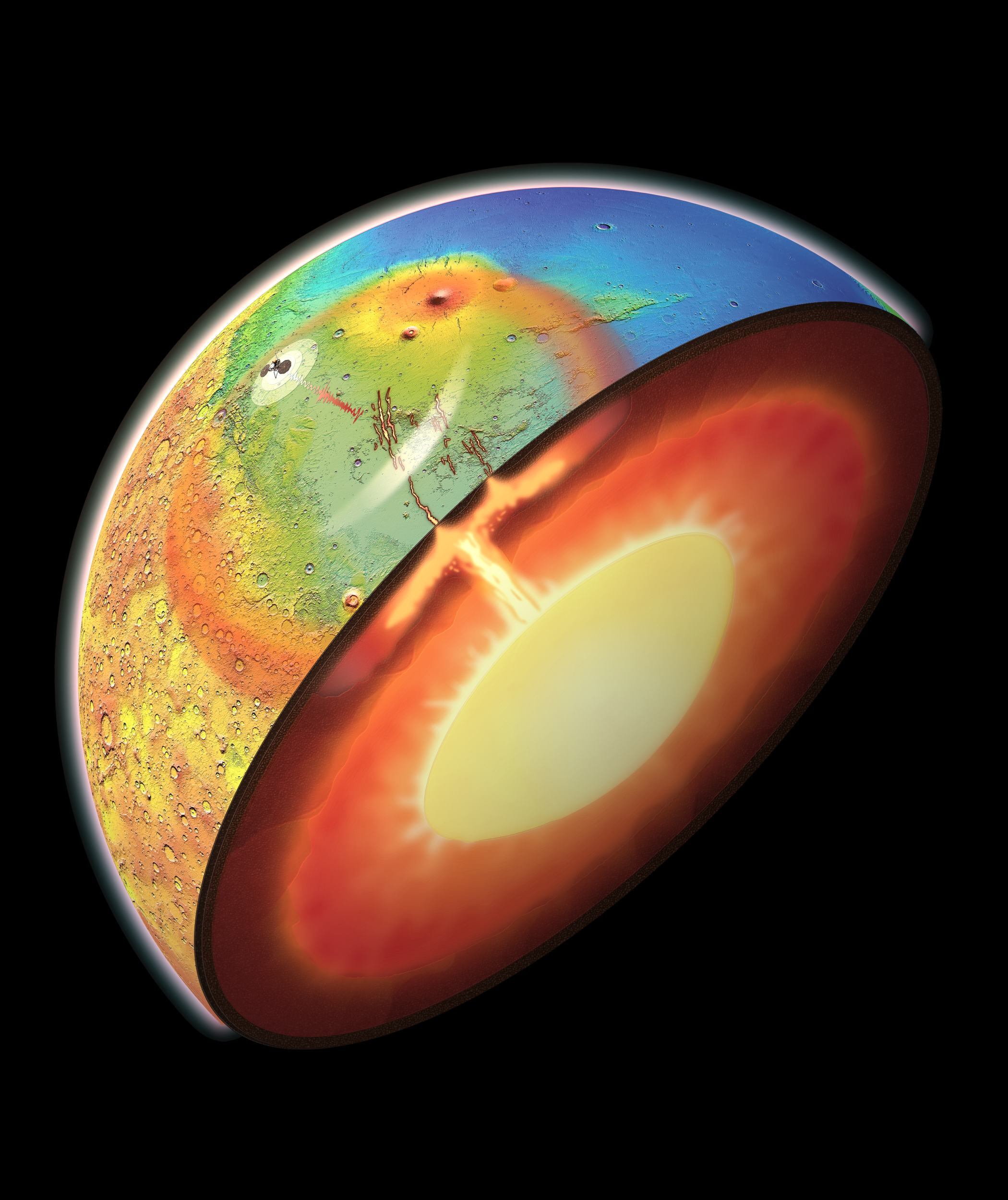
Although the majority of volcanic and tectonic activity on Mars occurred during the first 1.5 billion years of its geologic history, recent volcanism, tectonism and active seismicity in Elysium Planitia reveal ongoing activity. However, this recent pulse in volcanism and tectonics is unexpected on a cooling Mars. Here we present observational evidence and geophysical models demonstrating that Elysium Planitia is underlain by an 4,000-km-diameter active mantle plume head. Plume activity provides an explanation for the regional gravity and topography highs, recent volcanism, transition from compressional to extensional tectonics and ongoing seismicity. The inferred plume head characteristics are comparable to terrestrial plumes that are linked to the formation of large igneous provinces. Our results demonstrate that the interior of Mars is geodynamically active today, and imply that volcanism has been driven by mantle plumes from the formation of the Hesperian volcanic provinces and Tharsis in the past to Elysium Planitia today.
- Plume-induced flood basalts on Hesperian Mars: An investigation of Hesperia PlanumA. Broquet, and J.C. Andrews-HannaIcarus, 2023
Hesperian Mars was characterized by a unique style of geodynamic activity that left crucial volcano-tectonic records in the form of extensive flood lavas covered by wrinkle ridges. Yet, little is known about the context of their formation. Here, we perform a tectonic and geophysical investigation of Hesperia Planum, a 1700-km-diameter volcanic plain covered by wrinkle ridges. Our tectonic analysis reveals that the planum has the highest density of wrinkle ridges on the planet and a characteristic compressional peak strain of about 3.20×10⁻³, almost 2 times larger than typical Hesperian compressional strains. We invert gravity and topography data and find that simple crustal loading and volcanism cannot explain the tectonic record. An additional source of deformation is thus required. We demonstrate that a loading sequence of plume-induced uplift, volcanism, and subsidence, following an evolutionary path similar to flood basalt provinces on Earth better fits the observations. This plume model is able to explain the peak strain, crustal thinning, and low relief of Hesperia Planum. The inferred plume head size (∼1400 km) and temperature anomaly (∼320 K) are consistent with large terrestrial plumes. Based on a fit to the tectonic record, we determine a plume center location that correlates with a cluster of wrinkle ridges, local crustal thinning, and a circular magnetic low, where the latter could be the result of a thermal demagnetization of the lithosphere in the presence of the ascending plume. Our analysis suggests that scattered mantle plumes could be at the origin of Hesperia Planum and other late Noachian to early Hesperian volcanic provinces within the highlands.
- The history of global strain and geodynamics on MarsJ.C. Andrews-Hanna , and A. BroquetIcarus, 2023
The tectonic record of Mars is dominated by compressional wrinkle ridges on volcanic surfaces, and these structures have been widely used as a record of tectonic and geodynamic evolution. This study analyzes the density of compressional tectonic structures and inferred strain as functions of time, using the lengths and heights of compressional ridges together with geologic estimates of surface age. Our analyses confirm an apparent peak in compressional strain in the late Noachian and early Hesperian, and comparatively lower values before and after. The lower tectonic strain in the early and middle Noachian relative to the early Hesperian reflects the incompleteness of the ancient compressional tectonic record of strain, as older surfaces should accumulate more strain than younger surfaces. This strain deficit necessitates other means of accommodating contractional strain in the ancient crust, including distributed strain and small-scale faulting. The abrupt decrease in the accumulated tectonic strain and strain rate after the early Hesperian reflects a rapid episode of global contraction followed by much lower rates, in conflict with models of steady-state mantle evolution. The decreasing strain rate may be explained by a changing mantle rheology due to volcanic outgassing. Alternatively, the strain history may be explained by the dominance of mantle plumes in the late Noachian and early Hesperian associated with the formation of Tharsis and the early Hesperian volcanic provinces, which could have led to a pulse of rapid contraction caused by disequilibrium cooling and volcanic outpourings. The tectonic record of strain on Mars – including the incomplete ancient record and evidence for strong departures from steady-state models – may have implications for the interpretation of the tectonic record and thermal evolution of other bodies as well.
- Investigation of Martian Regional Crustal Structure Near the Dichotomy Using S1222a Surface-Wave Group VelocitiesZ. Xu , A. Broquet, N. Fuji , and 7 more authorsGeophysical Research Letters, 2023
Knowledge of Martian crust and uppermost mantle aid us studying the planet’s evolution. NASA’s InSight mission provides seismic data being used to reveal the interior structure. Most studies have focused on the crustal structure beneath InSight lander, but the seismic structure of other regions has remained poorly known. We use surface-wave data to investigate the crustal structure of a large region along the Medusa Fossae Formation and the dichotomy. We adopt the largest-magnitude marsquake (S1222a) that has been recorded, which provides both Rayleigh- and Love-wave signals. We measure and jointly invert these surface-wave fundamental-mode group velocities from ∼15 to 40 s to estimate the average 1D isotropic velocity models. These models includes a high-velocity layer at ∼7-km depth, which could be due to a regional basaltic activity or regional stress. Our models also indicate that a common intra-crustal structure (∼12–40 km depth) may exist in this region along the dichotomy.
2022
2022
- InSight Constraints on the Global Character of the Martian CrustM. A. Wieczorek , A. Broquet, S. M. McLennan , and 23 more authorsJournal of Geophysical Research: Planets, 2022
Analyses of seismic data from the InSight mission have provided the first in situ constraints on the thickness of the crust of Mars. These crustal thickness constraints are currently limited to beneath the lander that is located in the northern lowlands, and we use gravity and topography data to construct global crustal thickness models that satisfy the seismic data. These models consider a range of possible mantle and core density profiles, a range of crustal densities, a low-density surface layer, and the possibility that the crustal density of the northern lowlands is greater than that of the southern highlands. Using the preferred InSight three-layer seismic model of the crust, the average crustal thickness of the planet is found to lie between 30 and 72 km. Depending on the choice of the upper mantle density, the maximum permissible density of the northern lowlands and southern highlands crust is constrained to be between 2,850 and 3,100 kg m−3. These crustal densities are lower than typical Martian basaltic materials and are consistent with a crust that is on average more felsic than the materials found at the surface. We argue that a substantial portion of the crust of Mars is a primary crust that formed during the initial differentiation of the planet. Various hypotheses for the origin of the observed intracrustal seisimic layers are assessed, with our preferred interpretation including thick volcanic deposits, ejecta from the Utopia basin, porosity closure, and differentiation products of a Borealis impact melt sheet.
2021
2021
- Upper mantle structure of Mars from InSight seismic dataA. Khan , S. Ceylan , M. Drieland D. Giardiniand P. Lognonné , and 25 more authorsScience, 2021
For 2 years, the InSight lander has been recording seismic data on Mars that are vital to constrain the structure and thermochemical state of the planet. We used observations of direct (P and S) and surface-reflected (PP, PPP, SS, and SSS) body-wave phases from eight low-frequency marsquakes to constrain the interior structure to a depth of 800 kilometers. We found a structure compatible with a low-velocity zone associated with a thermal lithosphere much thicker than on Earth that is possibly related to a weak S-wave shadow zone at teleseismic distances. By combining the seismic constraints with geodynamic models, we predict that, relative to the primitive mantle, the crust is more enriched in heat-producing elements by a factor of 13 to 20. This enrichment is greater than suggested by gamma-ray surface mapping and has a moderate-to-elevated surface heat flow.
- Thickness and structure of the martian crust from InSight seismic dataB. Knapmeyer-Endrun , M. P. Panning , F. Bissig , and 36 more authorsScience, 2021
A planet’s crust bears witness to the history of planetary formation and evolution, but for Mars, no absolute measurement of crustal thickness has been available. Here, we determine the structure of the crust beneath the InSight landing site on Mars using both marsquake recordings and the ambient wavefield. By analyzing seismic phases that are reflected and converted at subsurface interfaces, we find that the observations are consistent with models with at least two and possibly three interfaces. If the second interface is the boundary of the crust, the thickness is 20 ± 5 kilometers, whereas if the third interface is the boundary, the thickness is 39 ± 8 kilometers. Global maps of gravity and topography allow extrapolation of this point measurement to the whole planet, showing that the average thickness of the martian crust lies between 24 and 72 kilometers. Independent bulk composition and geodynamic constraints show that the thicker model is consistent with the abundances of crustal heat-producing elements observed for the shallow surface, whereas the thinner model requires greater concentration at depth.
- The Composition of the South Polar Cap of Mars Derived From Orbital DataA. Broquet, M. A. Wieczorek , and W. FaJournal of Geophysical Research: Planets, 2021
The flexure of the lithosphere under stresses imposed by the geologically young south polar cap is one of the few clues we have regarding the south polar cap composition and the present-day thermal state of Mars. Here, we combine radar, gravity, and topography data with a flexural loading model to estimate the bulk density () and average real dielectric constant () of the south polar cap, and the elastic thickness of the lithosphere (). Given the uncertainties of the data, our results constrain to be 1,100–1,300 kg (best fit of 1,220 kg ), to be 2.5–3.4 (best fit of 3.3), and to be greater than 150 km (best fit of 360 km). Based on these results, the maximum lithospheric flexure is 770 m, and the polar cap volume could be up to 26% larger than previous estimates that did not account for lithospheric flexure. Our inferred compositions imply that the dust concentration would be at least 9 vol% if the ice content were negligible, and that the ice concentration would be more than the known 1 vol% if the dust concentration were less than 9 vol%. The 1- lower limit on implies a surface heat flow that is less than 23.5 mW . This lower limit is significantly less than the range of acceptable values at the north pole (330–450 km, heat flow of 11–16 mW ), and helps satisfy global thermal evolution simulations that predict hemispheric differences in surface heat flow.
2020
2020
-
 Flexure of the Lithosphere Beneath the North Polar Cap of Mars: Implications for Ice Composition and Heat FlowA. Broquet, M. A. Wieczorek , and W. FaGeophysical Research Letters, 2020
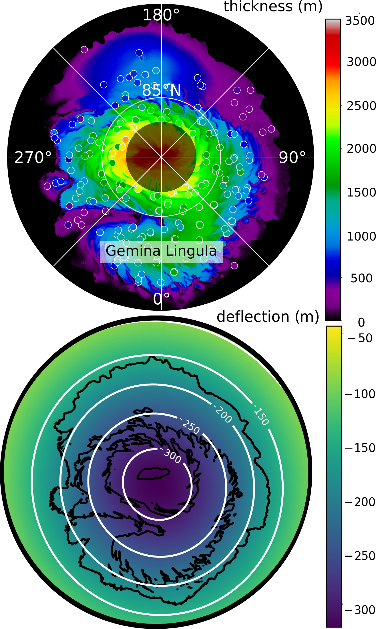
The geodynamical response of the lithosphere under stresses imposed by the geologically young north polar cap is one of the few clues we have to constrain both the polar cap composition and the present-day thermal state of Mars. Here we combine radar data with a flexural loading model to self-consistently estimate the density (rho) and real dielectric constant (e) of the polar cap, and the elastic thickness of the lithosphere underneath (Te). Our results show that rho ranges from 920 to 1,520 kg m-3, e is 2.75 (+0.40, 0.35), and Te is between 330 and 450 km. We determine a polar cap volume that is up to 30% larger than current estimates that all neglect lithospheric flexure. Our inferred compositions suggest that, for dust content larger than about 6 vol%, 10 vol% CO ice is mixed within the polar deposits, which has important implications for the climate evolution of Mars.
2019
2019
- The Gravitational Signature of Martian VolcanoesA. Broquet, and M. A. WieczorekJournal of Geophysical Research: Planets, 2019
By modeling the elastic flexure of the Martian lithosphere under imposed loads, we provide a systematic study of the old and low-relief volcanoes (>3.2 Ga, 0.5 to 7.4 km) and the younger and larger prominent constructs within the Tharsis and Elysium provinces (<3 Ga, 5.8 to 21.9 km). We fit the theoretical gravitational signal to observations in order to place constraints on 18 volcanic structures. Inverted parameters include the bulk density of the load, the elastic thickness required to support the volcanic edifice at the time it was emplaced (Te), the heat flow, the volume of extruded lava, and the ratio of volcanic products that form within (Vi) and above the preexisting surface (Ve). The bulk density of the volcanic structures is found to have a mean value of 3,206±190 kg/m3, which is representative of iron-rich basalts as sampled by the Martian basaltic meteorites. Te beneath the small volcanoes is found to be small, less than 15 km, which implies that the lithosphere was weak and hot when these volcanoes formed. Conversely, most large volcanoes display higher values of Te, which is consistent with the bulk of their emplacement occurring later in geologic history, when the elastic lithosphere was colder and thicker. Our estimates for the volumes of volcanic edifices are about 10 times larger than those that neglect the flexure of the lithosphere. Constraints on the magnitude of subsurface loads imply that the ratio Vi/Ve is generally 3:5, which is smaller than for the Hawaiian volcanoes on Earth.